3 title boundaries · 17,130 m² · LINZ

5 Queens Parade, Devonport

Auckland · Auckland

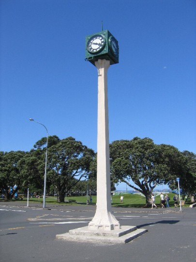
Alison Clock
Heritage listCategory 2 historic place

Alison Clock

List No. 4513Built 1928–1989Listed 2006

Located close to the wharves of the Devonport Steam Ferry Company in Devonport, the Alison Clock was erected in 1928 to commemorate the services of Hon. E.W. Alison, MLC, a prominent local politician and the ferry company's founder. The monument was largely funded by the wider local community, but with a contribution from the Council. The structure was designed by the renowned architect, Roy Lippincott, and unveiled in October 1928.

Read the entry on the Heritage List →

Photo: Martin Jones, 2005, © Heritage New Zealand Pouhere Taonga
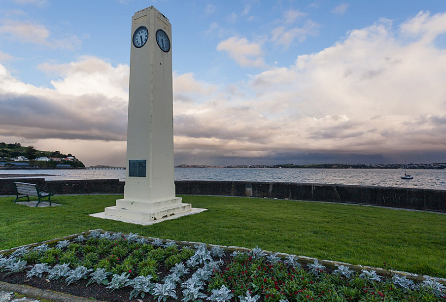
Watson Memorial, Devonport, Auckland. CC BY-SA 2.0 Image courtesy of www.flickr.com
Heritage listCategory 2 historic place

Watson Memorial

List No. 4517Built 1936–1980Listed 2006

The Watson Memorial was constructed in 1936 by Devonport Borough Council, in remembrance of Alexander Richardson Dickey Watson (c.1878-1917), a major local public benefactor. Its construction was part of a programme of beautification along Devonport's esplanade, converting the landscape from a rocky seashore and place of commercial activity to a site of genteel perambulation and other forms of recreation.

Read the entry on the Heritage List →

Matched to this property by the list's map position. Check the entry's address: King Edward Parade, Devonport, AUCKLAND.

Photo: russellstreet, 2011, © russellstreet - Wikimedia Commons

What you’ll love about this place

  • Waterfront: the land runs down to the coast

From LINZ's topographic maps: how near the land comes to the water's edge.

Every sale and rating valuation published for this property, newest first. No sale on record yet.

A rating valuation is the council's figure for apportioning rates, not a market appraisal. Sale prices are as published; a code beside a price is the council's sale type — hover it for what it means.

My notes
Thinking of buying?Free pre-purchase running cost report Mortgage repayments, this year’s council rates, and estimates for insurance, electricity, gas and internet at this address — saved to your watchlist.
Sign in for the free report
What it costs to live here

Home expense estimates

—a month, all in

Estimates from the floor area and typical New Zealand prices, not quotes. Power, gas and internet details from the Electricity Authority and Gas Industry Co registries and Chorus.

Home loan

What it would cost to buy 5 Queens Parade

Every rate from 36 lenders →
Estimated repayments
—
$0 at 4.49% 1 year fixed with China Construction Bank, over 30 years
Loan length
1 year fixed today · 17 lenders
Lowest4.49%CCB · special
Average5.03%
Highest5.35%Kookmin
All 17 lenders at 1 year fixed
  • China Construction Bank4.49%s
  • ICBC4.65%s
  • Bank of China4.68%s
  • AIA New Zealand4.99%
  • ANZ Bank New Zealand4.99%s
  • ASB Bank4.99%
  • Bank of Baroda4.99%
  • Police Credit Union4.99%
  • Unity Credit Union4.99%s
  • Kiwibank5.15%s
  • Bank of New Zealand5.19%
  • SBS Bank5.19%s
  • The Co-operative Bank5.19%s
  • TSB Bank5.19%s
  • Westpac New Zealand5.19%s
  • First Credit Union5.29%s
  • Kookmin Bank Auckland Branch5.35%
Brokers can often beat the advertised rate Tell us a few things and mortgage brokers compete to finance 5 Queens Parade. Free for you — lenders pay brokers — and nobody sees your name until you choose one.

Principal and interest at the lowest advertised card rate, held for the whole loan — no New Zealand rate is. A guide, not a lending offer or financial advice. How much could you borrow? · Mortgage calculator

Property data

  • Property categoryUse not published
  • CouncilAuckland
  • Valuation #02650-00000098801

From the council’s rating records and the other sources noted on hover. Bedrooms and bathrooms may come from a past listing. Built is the decade the valuer records.

  • Title numbersNA2D/86, NA511/11, NA616/104
  • Title typeFreehold
  • Registered ownerAuckland Council
  • Public landHeld by a council
  • Estate descriptionFee Simple, 1/1, Allotment 40 Section 2 Parish of Takapuna, 2,276 m2
  • Legal descriptionAllotment 40 Section 2 Parish of Takapuna; Lot 1 Deposited Plan 22936; Portions of the Waitemata Harbour reclaimed or intended to be reclaimed from the sea
  • Title issued30 Nov 1964
  • Land districtNorth Auckland
Instruments on these titles5 registered instrumentsOther ×2 · Deed of Easement · Lease · Proclamation See the title summary →

Owners and the parties to each instrument are not published on this page. Order the record of title to see them.

Getting around
Ferry terminal
Ferry Terminal - Devonport
2 min walk · 101 m · about every 20 min
DEVMTIARANG
Bus stop
Devonport Terminal
1 min walk · 2 m · about every 5 min
805806807814
Stops: Auckland TransportWalk times estimated, not routed

Listings

Selling this property, or the agent for it? Import the listing from your agency's site or a portal and it appears here, free: photos, price, open homes and your details, beside the council record buyers are already reading.

Building consents

We hold no building consents for this property yet. The council may hold records we have not seen.

Resource consents

What the council has been asked to allow under the Resource Management Act. None on this property · 16 land use or subdivision consents within 250 m.

Within 250 m

  1. 10 Dec 2024
    Land use

    To consent emergency works involving the renewal of 300mm of ceramic stormwater pipeline which included the construction of two new 1050mm manholes within the road reserve adjacent to 1 Victoria Road,

    LUC60441581 · Auckland
    101 mGranted
  2. 31 Aug 2023
    Land use

    Parks and Community Facilities Auckland Council as Applicant proposes to install a free standing outdoor power box in the Windsor Reserve, Devonport to provide a power point for use for events held at the band rotunda in the reserve.

    LUC60422652 · Auckland
    247 mGranted
  3. 15 Aug 2023
    Land use

    Upgrade of an existing telecommunications facility on the rooftop of the scheduled heritage building 1120 , The Esplanade Hotel, at 1 Queens Parade, Devonport. The upgrade is within the Height Sensitive Area for Mount Victoria. Application is part of a bundled co nsent for the upgrade of six One NZ Fortysouth sites within the Volcanic Viewshaft and Height Sensitive Areas overlay.

    LUC60422066 · Auckland
    101 mGranted
  4. 16 Dec 2022
    Land use

    Additions and alterations to a dwelling within a special character area, flood plain and coastal inundation area

    LUC60413616 · Auckland
    225 mGranted
  5. 2 May 2022
    Land use

    The Auckland Council Community Facilities Department proposes to install electricity to the band stand and install a new concrete path, paving and associated features in the Windsor Reserve, Devonport.

    LUC60401493 · Auckland
    247 mGranted
  6. 26 Nov 2021
    Land use

    s127 - Condition 1 Remove existing chimney without replacement

    LUC60374642-A · Auckland
    198 mGranted

Ministry for the Environment, National Monitoring System, July 2014 to June 2025. All resource consents

Unclaimed
Nobody is tracking this property yet

If it is yours, claiming it puts the council record, the title and what it costs you to hold in one place — and lets you put your lending, insurance and power out to people who compete for them.

Free. Takes about a minute.

We check your name against the registered owner on the title before a claim is accepted. Nothing on this page changes for anyone else, and no provider is contacted until you ask.

What claiming gets you
1One live recordCouncil valuation, title details and registered interests, kept current rather than gathered again every time you need them.
2Your lending in the pictureAdd what you owe, or connect the bank, and the equity and LVR stop being a calculation you redo by hand.
3Providers compete for itPut the mortgage, the insurance and the power out to people who want the business — on your terms, when you ask.
4Everything else you ownOne search finds other titles in your name and in companies you are a director of.

Zoning and hazards

What the council's published maps say about this land. A map is a model of a storm, not a record of one: a LIM or a flood report says more.

Part of this property is inside a mapped flood area.

  • Unitary Plan Base Zone

    On this property
    Over the whole section

    District plan zones as Auckland publishes them. What a site may be used for, and what may be built on it.

  • Flood plain

    On this property
    Over about 8% of the section

    Land the council models as under water in a 1-in-100-year storm, usually with an allowance for climate change.

    Modelled
    2026
    Climate allowance
    Yes - MfE2018 3.8 degrees
    Development assumed
    MPD Auckland Unitary Plan OiP 2016
  • Flood prone area

    On this property
    Over about 10% of the section

    A low point where stormwater ponds if its outlet blocks or overflows.

    Depth in a 1-in-100-year storm
    0.37–0.68 m
    Depth before it spills
    0.37–0.68 m
    Water level (NZVD2016)
    2.51–2.9 m
  • Flood sensitive area

    Not mapped here
    None within 250 m

    Land beside a flood plain that could flood if the model is out, or the storm is bigger.

  • Coastal inundation

    On this property
    Over about 85% of the section

    Land the sea reaches in a 1-in-100-year storm tide once sea level has risen by 1 m.

    Chance each year
    1.0 %
    Sea level rise assumed
    1 m
  • Special character area

    Nearby
    1 m from the boundary

    Streets whose built character is protected: demolition and new building are assessed against the area's existing form, whatever the zone allows.

  • Historic heritage place

    On this property
    Over about 18% of the section

    A scheduled historic place. Work on it, including demolition, needs consent against the heritage schedule.

    Place
    Watson Memorial Clock, E.W. Alison Memorial and clock, Commemorative sea wall…
    Schedule
    1149–2125
  • Height variation control

    Nearby
    30 m from the boundary

    An explicit building height for this land, replacing the one its zone would give.

  • Volcanic viewshaft

    On this property
    Over about 81% of the section

    A protected view of a volcanic cone. Inside it, building height is capped at a fixed level above sea level to keep the cone visible.

    Viewshaft
    Mount Victoria, Rangitoto Island, Mount Hobson…
    Control
    Height Sensitive Areas, Viewshafts
  • Locally significant viewshaft

    Not mapped here
    None within 250 m

    A locally protected view of a cone, with its own height ceiling.

  • Museum viewshaft

    Not mapped here
    None within 250 m

    The protected view of the Auckland War Memorial Museum.

  • Ridgeline protection

    Not mapped here
    None within 250 m

    Skyline land where building height is controlled so the ridge stays a ridge.

  • Notable tree

    Nearby
    29 m from the boundary

    A scheduled tree. It may not be felled or topped without consent, which makes it a permanent part of the skyline.

  • Notable group of trees

    Not mapped here
    Nearest 106 m away

    A scheduled stand of trees, protected as a group.

  • Precinct

    On this property
    Touches the edge of the section

    Local rules written for this area alone, which override the underlying zone where they differ.

    Precinct
    Devonport Naval Base sub-precinct B

Source: Auckland Council (CC BY 4.0)

Contaminated land

Councils keep registers of land used for activities on the Hazardous Activities and Industries List (HAIL) — service stations, timber treatment, orchards, landfills. A listing records how land was used, not that it is contaminated: most sites have never been tested.

Auckland Council does not publish its contaminated sites records. A site contamination enquiry (a fee applies) or the LIM will say what it holds.

Ask Auckland Council

What could you build here?

See whether a granny flat fits beside the house: the Building Act exemption, the national granny flat rules and the zone’s own. Then ask builders to price the shape you pick.

About Devonport

Auckland
2,776
Properties on the rating roll
1 May 2024
Last council revaluation
Buyer demand

7 people looked at properties in Devonport this week.

Counts describe the records we hold for this territorial authority, not a market forecast. OwnBetter has no estimate for this property. Every council figure on this page can be checked against the council's own record.

Agents active in Devonport

People whose office is within 5 km of Devonport, nearest first. Taken from the REA public register -- not ranked by sales, and nobody pays to appear here.

Who sold the most in Devonport →
Free for property owners

Claim it, then find everything else you own.

A single search across NZ property records finds other titles in your name and in companies you are a director of. Most owners find at least one they had forgotten was held somewhere else.

Find all my properties